There is considerable confusion with respect to the terms of urban geography, not only among the population in general, but also among the media, and sadly, among academics. Perhaps the greatest confusion is between the terms “metropolitan area” and “urban area.”
Metropolitan areas (census metropolitan areas in Canada, or CMAs) are labor markets, which are defined by commuting patterns. They include both urban and rural areas. They are not to be confused with built-up urban areas (called “population centres” in Canada), that contain only urban land. In Canada, population centres have a minimum population of 1,000.
All land within Canada (according to Statistics Canada), the United States (according to the US Census Bureau) or the World (according to the United Nations) is either urban or rural. But it may be surprising to that most land in metropolitan areas is rural.
After the 2010 US Census, we published an article examining the rural extent of metropolitan areas“ (Rural Character in America’s Metropolitan Areas), finding that about 90% of their land was rural (non-urban). Nearly the same is true of Canadian census metropolitan areas (CMAs). According to the 2021 census, 87.0% of the land in the 42 CMAs is rural. Only 13.0% of the land isurban (in population centres). Among the major CMAs (over one million population) the average the rural land area average is 76.8%, with 23.2% in urban land. Among the major CMA’s Montreal has the least rural land, at 62.4%.
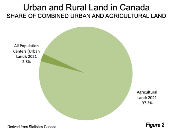
Comparing Trends: Urban Land and Agricultural Land
The extent of urban land has been increasing for decades, as urban population has increased. This has led to concerns that expanding urbanization is reducing the amount of agricultural land. But, in fact, land has been taken out of agricultural production at a far faster rate than can be explained by the increase in urban land.
Between the 2016 and 2021 censuses, Canada’s urbanization, measured by population centres, increased by less than 1,200 square kilometers. Total agricultural land was reduced by more than 20,000 square kilometers. The reduction in agricultural land was more than 17 times the addition of urban land. The reality is that agricultural land has been withdrawn from Canada for decades, according to Statistics Canada data, just as it has been in the United States, Australia and other nations because much land has become less productive even as productivity has continued to improve.
Even more starkly, the land area of the urbanization that has developed in Canada since the dawn the first European settlement is less than the reduction in agricultural land in just five years. Overall, population centres covered nearly 18,000 square kilometers in 2021. By comparison, the reduction in agricultural land was 20,000 square kilometers between 2016 and 2021.
All of Canada’s urban land in 2021 is equal to about three percent of the total agricultural land, according to Statistics Canada data (Figure 2).
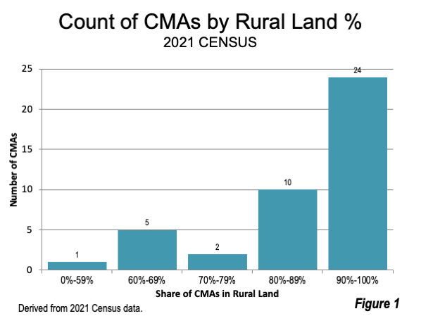
CMAs by Extent of Rural Land
Figure 1 indicates the number of CMAs by the share of urban land within their borders and the Table provides data for all CMAs.
CMAs with 90%-100% Rural Land
More than one-half — 24 of the CMAs consist of more than 90% rural land. Kamloops (BC) has the largest expanse of rural land, at 98.6% of the CMA total. Fredericton, New Brunswick’s capital is close behind, at 98.4%. Four more CMAs are at least 97% rural, including Chatham-Kent, Ontario (97.7%), Lethbridge, Alberta (97.5%), Saskatoon, Saskatchewan (97.4%), Regina, capital of Saskatchewan (97.2%) and Thunder Bay, Ontario (97.0%).
Two CMAs with more than one million residents are at least 90% rural. These are Edmonton (1.4 million), capital of Alberta, at 91.4% and Ottawa-Gatineau (1.5 million), location of national capital, at 91.0%. Winnipeg, capital of Manitoba (835,000) is 92.8% rural. Halifax, capital of Nova Scotia (470,000) is 96.3% rural.
CMAs with 80%-89% Rural Land
Ten CMAs have between 80% and 90% of their land in rural areas. The largest of these CMAs are Calgary, with 1.5 million residents is 86.3% rural. The Quebec City CMA (840,000) is 86.2% rural. St. Catharines-Niagara (435,000) is 80.9% rural. Windsor (420,000), across the Detroit River from Detroit, is 86.7% rural.
CMAs with 70%-79% Rural Land
Two CMAs are between 70% and 79% rural. Both are adjacent to Toronto. Hamilton, with a population of 785,000, is 73.4% rural, while Oshawa, with a population of 415,000 is 78.7% rural.
CMAs with 60%-69% Rural Land
Five CMAs have from 60% to 69% of their land in rural areas. These include the three largest CMAs. Toronto, with a population of 6.2 million, and the largest CMA in Canada, is 64.3% rural. The second largest CMA, Montreal, with a population of 4.3 million, is 62.4% rural. The third largest CMA, Vancouver has a population of 2.6 million is 65.3% rural. The Kitchener-Cambridge-Waterloo has a population is 69.7% rural. The other CMA with between 60% and 69% rural land is Victoria, the capital of British Columbia, and has a population of nearly 400,000.
CMAs with Under 60% Rural Land
Only one CMA has less than 60% of its land in rural areas — Red Deer, Alberta, which is only 37% rural. Red Deer is the smallest CMA of the 42, with a population of 100,000, barely meeting the CMA minimum population criteria.
Remote Work to Increase CMA Rural Areas
There may be the prospect of CMAs becoming even more rural. During the pandemic, remote work replaced working on site in Canada and other nations. The latest data indicates that more than 20% of workers were spending the majority of their work time at home. This is about three times the work at home share from the 2016 census.
Remote work makes it possible for households to conveniently live farther from employment locations, with larger houses, home offices and yards. Strong decentralizing trends were observed by Statistics Canada between 2016 and 2021, when three-quarters of CMA population growth was in the suburbs. In the largest CMA, Toronto, nearly three-quarters of growth was in the distant suburbs. Richard Florida of the University of Toronto and famous for his identification of the “creative class” recently told The New York Times that “now here’s a whole generation leaving cities again, for metropolitan or virtual suburbs,” Decentralization, long the dominant trend seems likely to intensify. The rural character of CMAs and could even become more pronounced.
Wendell Cox is principal of Demographia, an international public policy firm located in the St. Louis metropolitan area. He is a founding senior fellow at the Urban Reform Institute, Houston, a Senior Fellow with the Frontier Centre for Public Policy in Winnipeg and a member of the Advisory Board of the Center for Demographics and Policy at Chapman University in Orange, California. He has served as a visiting professor at the Conservatoire National des Arts et Metiers in Paris. His principal interests are economics, poverty alleviation, demographics, urban policy and transport. He is co-author of the annual Demographia International Housing Affordability Survey and author of Demographia World Urban Areas.
Mayor Tom Bradley appointed him to three terms on the Los Angeles County Transportation Commission (1977-1985) and Speaker of the House Newt Gingrich appointed him to the Amtrak Reform Council, to complete the unexpired term of New Jersey Governor Christine Todd Whitman (1999-2002). He is author of War on the Dream: How Anti-Sprawl Policy Threatens the Quality of Life and Toward More Prosperous Cities: A Framing Essay on Urban Areas, Transport, Planning and the Dimensions of Sustainability.
Photo: Saskatchewan River, downtown Edmonton. The Edmonton CMA has largest rural and component of any major CMA in Canada, at 91.4%, according to the 2021 Census (by author).
Republished from www.newgeography.com